The Project ‘Norwegian Tourist Roads’ was started 21 years ago. Trollstigen (The Troll Ladder) is one of Norway’s most important sights and the biggest of the 18 projects.
Each of the 18 National Tourist Routes has its particular characteristics and passes through landscapes with unique natural features along the coast and fjords, by mountains and waterfalls, from Jæren in the south to Varanger in the north. On these stretches you will find viewing points, rest areas, architecture and artworks that enhance the experience of the beautiful landscape through which you are driving.
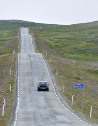
National Tourist Route Varanger runs from Varangerbotn to Hamningberg, a total distance of 160 km (Road 75/341). Experience one of Norway’s most beautiful round trips by combining this route with the Hurtigruten coastal express and National Tourist Route Havøysund.
Varanger is about the long lines in the landscape as well as the long lines of history. Varanger not only offers a physical experience; you will also find serenity on this road. It is difficult to explain other than by saying that this is a place where you feel as if time stands a bit still. You drive past birch woods, marshland and a rugged cliff landscape.
The light is special and the bird and animal life are unique. Species of birds that you can’t see anywhere else in the world are relatively easily accessible. It’s not only because of its geographical location that Varanger is perhaps the most exotic stretch.
A trip along the route leading to the Arctic Ocean will reveal natural surroundings full of contrasts, and the lunar landscape out towards Hamningberg in many ways feels like this is a journey to the world’s end. If you drive along this road in the autumn perhaps you will experience the steely grey light, and the barren landscape will emerge as even more magical.
History
History is not always pretty and at the Steilneset memorial we encounter episodes of history that may be difficult to comprehend. The witch trials in Finnmark in the 17th century claimed 91 victims and it was here that the greatest number of people were found guilty of witchcraft and burnt at the stake. Its closeness to Russia, immigration from Finland and Sámi traditions pervade this area with an exciting cultural diversity.

Experience
Even if you’re not a bird-watching enthusiast, you should take time to observe some of the rare bird species here. Along this stretch of road, several bird-watching hides have been built where you can sit well sheltered against the vagaries of the weather while you marvel at the landscape. There’s also a good chance of experiencing reindeer at close hand on this road. After visiting the Steilneset memorial you should drop by the picturesque Vardøhus Fortress that lies at the easternmost point of Norway.

Havøysund
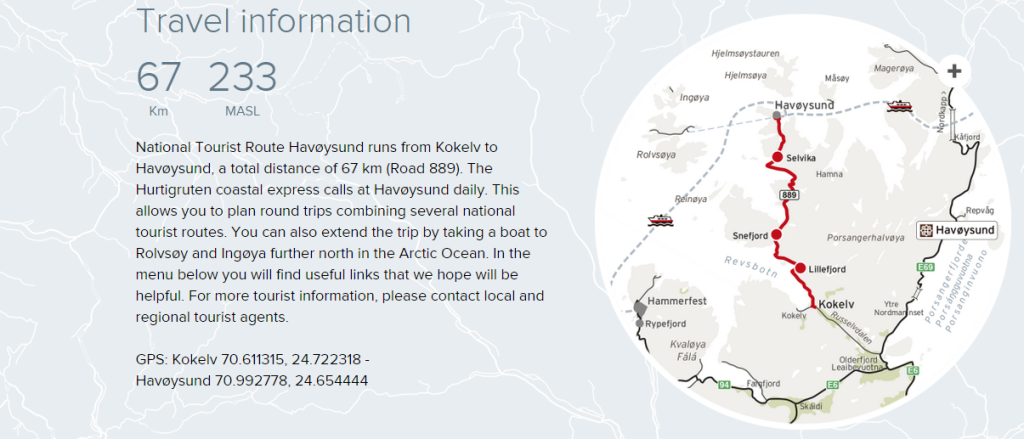
The road out to Havøysund is fascinatingly varied and even though it is only a couple of hundred metres above sea level at the highest point, you get the feeling of driving above the tree line. Parts of the road traverse a barren rocky landscape with the Arctic Ocean on one side and rugged outcrops on the other.
The landscape is stark and dramatic and there are few signs other than the road to show that anyone has ventured here before. But in the middle of this apparently barren land you can actually spot both sea eagles and reindeer. The drive offers a varied and thrilling experience that is without comparison – with a picturesque, unique final stop.
The little fishing village of Havøysund located at 71° north is literally the end of the road. The village suddenly pops up, taking you by surprise. Strange to think that there is a viable community situated at the spot where the northernmost point of the national tourist routes ends on the edge of the ocean. That is quite something.
History
For several hundred years people have defied wind and weather and clung to the outermost point of the coast of Finnmark, but it was only at the end of the Second World War that Havøysund became an important fishing community. There was a large fishing fleet consisting of everything from small fishing smacks to large trawlers, and fish landing stations and fish processing plants were established there.
Experiences
The ocean and fisheries have been the principal industry for people living in the North, and deep-sea fishing also attracts many people to the area. This stretch is also perfect for those who want to cycle in an extraordinary landscape. The Havøysund plateau is just as far north, but it gets far fewer visitors than the North Cape. Here on the edge of the Barents Sea you can experience the midnight sun in summer and the northern lights in winter.
Senja
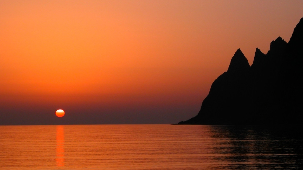
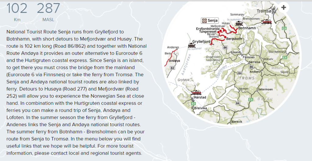
The steep mountains plunging deep into the ocean are a breathtaking sight and the most prominent feature of this stretch. The road is narrow here and there as it twists and turns along fjords with crystal clear, icy-cold waters. So cold that no matter how inviting the beaches with their pure white coral sand appear, going for a swim is only for the hardiest among us.
At Bergsbotn you will find a viewing platform that lifts you above the magnificent surroundings, allowing you to look out over Bergsfjorden to the ocean in the background. The drive continues in a dramatic landscape on a road which is occasionally quite narrow and winding, and you will find tiny fishing villages and houses clinging to the most surprising spots.
Senja reflects the robustness and hardship of a time when people had to survive on fishing and agriculture that yielded little, but the island also reveals a less harsh side with its sheltered fjord inlets. And above all, it is so beautiful that you will wonder why you haven’t found your way here before.
History
It’s not just the scenery that is special on Senja. The story-telling tradition is not something you can spot from your car window, but it is as rich as the landscape. Two of the best-known stories are Senjatrollet – the tale of the troll who was seen on both land and sea, and Mannen i Ausa – the story of how the Ausa mountain acquired a face as well as eyes. Amid the stunning scenery daily life was hard for those who lived here, and this is also reflected in the stories.
Experiences
Senja is like an enormous playground for outdoor types who like a challenge. For everyone who wants to do hiking, paddling, diving or freeriding down steep hills, Senja is an eldorado. There are ample opportunities to explore nature. There are also less demanding activities that both big and small can find pleasure in. Find one of the many lovely beaches, follow the ebb of the water and run back when the waves crash into shore without being caught by the icy-cold water. Sometimes that’s all it takes to have fun.
Andøya
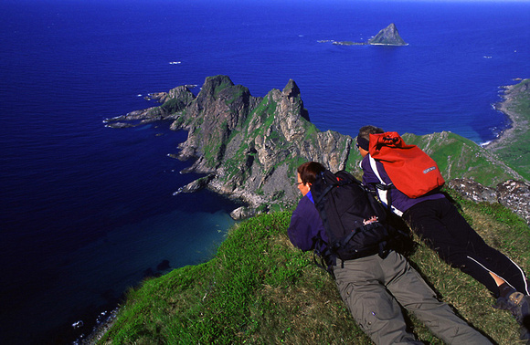
On the island of Andøya you can wander along some of Norway’s most beautiful beaches and look out over the still waters of the ocean with the midnight sun as your sole companion.
This is a trip that is designed for enjoyment. The road itself follows a broad shelf of cultivated land where people have put down roots between the wide ocean and the jagged peaks. If you’re lucky you might see seals, whales and eagles from your car window. In the late summer you can try tasting wonderful cloudberries on the moorland that stretches towards the mountains, or earlier in the summer you can visit the bird cliff on the island of Bleiksøya.
The Gulf Stream makes for a hospitable climate and turns the ocean into an abundant source of food for a rich variety of bird and animal life. Here you can also discover some little-known highlights such as the tiny fishing village of Bleik. Between Nordmæla and Nøss you will find the rock formation Bukkekjerka, where nature itself has contrived to build a natural altar and pulpit. Andøya also provides a fine stretch of road for cyclists and if you want to view the island from the sea, there are lots of opportunities for kayaking.
History
Fishing and fish processing have been Andøya’s main industries but the climate has also favoured agriculture. The armed forces have played an important role in the community, and the air-base was built with NATO funds. Andenes lighthouse has been a landmark since 1859.

Experiences
Spaceship Aurora is a completely new attraction for the public at the Andøya Space Center enabling you to learn more about outer space and the northern lights. Maybe not everyone thinks of Norway as a space nation but since the launching of its first research rocket in 1962, Andøya has been at the centre of an exciting part of our space travel history. For those who prefer dry land, picking cloudberries or bird watching are good alternatives. If you prefer the sea, we recommend deep-sea fishing or a whale safari – both great alternatives.

Lofoten
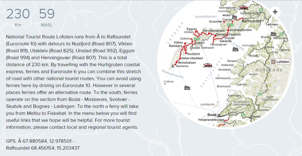
Regardless of the time of year, Lofoten provides a journey amid breathtaking natural surroundings. The landscape is both beautiful and stark. However there are sheltered, protected stretches that can provide some relief from the raw, exposed areas that show their harshness when the wind is blowing hard.
The combination of the untamed ocean and stormy seas, jagged alpine mountains plunging into the water, tiny sheltered fishing villages and white beaches with crystal clear waters will never cease to enchant us. That’s also the reason why the road can be so busy in the high season. Then it’s good to know that you can seek out little, secluded corners and fine detours along the route. There are also many tourists who have discovered that winter can be just as beautiful as summer. The Arctic winter is the perfect time to see the northern lights, an overwhelming play of light and colour.
You are guaranteed a unique experience with fewer people to share it with. No matter what time of year you decide to visit Lofoten, you will experience its distinctive qualities, and for many people Lofoten leaves lasting memories. If you are a fitness enthusiast who at worst can put up with a puff of wind or a shower of rain, cycling is a good alternative to driving on Lofoten.
History
Lofoten is particularly well known for its cod fisheries. Between February and April, huge quantities of cod migrate to Lofoten to spawn. Throughout the centuries this has provided an economic basis for the local population. Stock-fish from the Lofoten fisheries was the first export product of economic importance for Norway.
Experiences
There are innumerable options for trips and you can choose how great a challenge you want. There is a variety of options and most are close and easily accessible. Even in the town of Svolvær and the fishing village of Henningsvær you are in close contact with the ocean and nature. It almost goes without saying that you should try your hand at the Lofoten cod fishing, or perhaps a sea eagle safari, a stimulating boat trip in a RIB boat, or you can do your own thing in a kayak or go snorkelling in the Arctic waters.

Helgeland Coast
The National Tourist Route Helgelandskysten is the longest of the 18 National Routes. The six ferry trips and the contrasts the route presents mean that you must set aside plenty of time for the drive. Going from Jektvik to Kilboghamn you cross the Arctic Circle at 66 degrees northern latitude.
On this journey you will also encounter many other unique natural phenomena. Saltstraumen is the world’s largest tidal maelstrom while Svartisen is Norway’s second largest glacier. You can also marvel at the hole through the Torghatten peak and ponder on whether the legend of the Seven Sisters is true. The road follows the coast but its character changes underway from the long line of peaks in the north to the fjords and mountains until the scenery becomes more gentle with the archipelago and the islands out at sea. Even in the fertile cultivated landscape to the south, the vicinity of the sea is essential to the experience.
Keep in mind that you can also see the midnight sun south of the polar circle, even though it just barely dips into the sea. The Vega Island features on UNESCO’s World Heritage list, but you can also pick another of the thousands of islands where you can experience something equally special. Four hundred kilometres abrim with natural and cultural experiences will have an impact on you ‒and will do you the world of good.
History
Along the coast of Helgeland the main livelihood of the population has been agriculture and fishing. This is still the case but there are other sides to the story. It’s all about exploiting the resources – hydropower, industry and mining operations – and about people who have sought to realize nature’s potential ever since the Stone Age. The Petter Dass museum is the millennium site of the County of Nordland and presents exciting exhibitions all year round. You will also find war memorials and war cemeteries along the route.

Experiences
Helgelandskysten is perfect for cycle trips – the terrain is flat and the roads are wonderful. You can take breaks wherever you want to. Since the landscape surrounding the mountains is fairly flat, the view from the summits makes the trip to the top very worthwhile. There is a wealth of trips to lofty mountain tops and to islands, and in the archipelago a kayak is a splendid means of transport. The multitude of islands ensures that you can paddle for long distances without having to cross wide expanses of open sea.

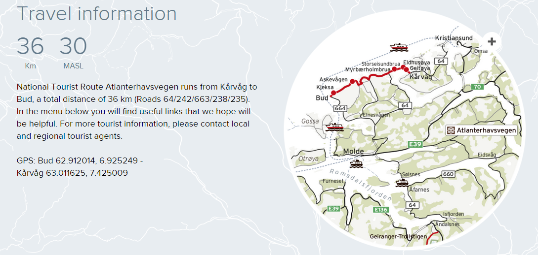
Atlantic Road
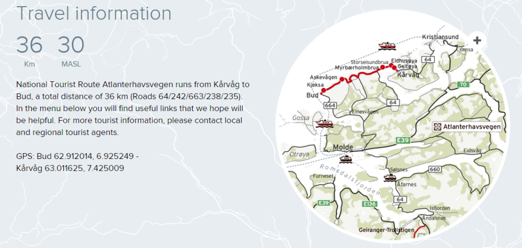
Nothing is as mighty as the ocean ‒ our most important transport route for centuries, a source of income and the starting point for innumerable recreational options. Few places bring you closer to the ocean and let you feel part of it in the same way as Atlanterhavsvegen.
Here you will feel the effects of winter storms and enjoy days of sunshine in the summer. The road is a visual delight as it curves elegantly from islet to islet over its seven bridges. The natural surroundings and feats of modern engineering combine to create a unique driving experience.
The trip takes you from the fertile cultural landscape of the coast across moorland to bare crags along the weather-beaten, open bay of Hustadvika.Take time to watch the sun disappearing below the horizon from here. Atlanterhavsvegen has been described as the world’s most beautiful car drive. It is an intense experience that will give you an insight into a harsh world where you must withstand a gust of wind.
History
The fisheries and wealth awaited in the open sea off Atlanterhavsvegen. The fishing industry needed better transport arteries to strengthen trade and export. The islanders on Averøy worked hard to put a road in place but it was not until 1983 that work commenced. Working conditions were very demanding and the construction workers experienced a total of twelve hurricanes during the six-year-long construction period. The road was opened in 1989, and in 2005 it was chosen as the Norwegian construction of the century.
Experiences
The proximity to the ocean dominates and on the fishing bridges you are guaranteed a catch. This is the place for everyone who loves angling, regardless of whether you are a hobby fisherman or a professional. If you have a diving certificate, we recommend a dive down to the dense forest of seaweed where you can experience the rich, exciting life underwater. At the end of the breakwater at Aksvågen you can feast your eyes on the view when the weather is good, and when storms roll in you can feel your body buffeted by the power of nature. Cycling along the road will expose you to the vagaries of the weather, the wind, the ocean and stunning natural experiences. You can also make short detours on the many coastal paths and experience even more of nature and the landscape.

Geiranger
The drive along Trollstigen is undoubtedly more dramatic than most people are used to, but what is special about driving in Norway is that in fact people live just about everywhere. Even on the narrowest mountain ledge or small crag there will be a house. We are bound to the landscape and the natural surroundings through settlements that have offered us a livelihood throughout history.
Geiranger-Trollstigen offers numerous highlights, and the eleven hairpin bends of Trollstigen as well as the view from Ørnesvingen down to the Geirangerfjord may set your pulse racing. Lush valleys, sheltered strawberry-growing areas, precipitous mountains and vantage points guaranteed to make you dizzy offer some of Norway’s most scenic views.
Allow plenty of time for the trip − stops are welcome whether you want the challenge of a hike to a lofty summit or just to enjoy the view. For those who take the time, there’s such a lot more to be discovered.
History
For several centuries the road was an important transport artery between Valldal and Åndalsnes, first as a path and then as a bridleway, until construction of the Trollstigvegen road started up in 1916. Parts of the original pack horse track are still visible and passable on foot. It’s an exciting alternative for everyone who would like to experience the road as it was in days of old.

Experiences
You will find some of the most sensational installations we have constructed on this stretch. Here, viewing points such as Ørnesvingen, Gudbrandsjuvet gorge and Flydalsjuvet gorge let you explore the natural surroundings in a unique manner. Taking the ferry on the Geirangerfjord will bring you up close to the well-known waterfalls of Dei Sju Systre, Friaren and Brudesløret while at the same time you will experience the most renowned fjord in the world – the Geirangerfjord, which is on UNESCO’s World Heritage List.
Traffic information: Single-lane traffic on county road 63 below Ørnesvingen due to a landslide.
encounter difficulties. The Norwegian Public Roads Administration therefore urges all road users to exercise caution.
Winter notice: The road is open for the summer. Parts of National Tourist Route Geiranger – Trollstigen are closed during the winter season. The stretch from Langevatnet -Geiranger is usually closed in November and reopens in May. Trollstigen is usually closed in October and reopens in May.
Red flags in the map In May, a landslide occurred 60 metres below county road 63 at Ørnesvingen between Geiranger and Eidsdal. The Norwegian Public Roads Administration has therefore closed one half of the road to traffic, which is routed through the other lane over a distance of approximately 35 metres. This single-lane solution will remain in place until October. A temporary guardrail will be installed, and the NPRA will ensure that manual traffic control is put in place if required. There may be queues of traffic, and buses may show where the road will be closed.

Gamle Strynefjell Route
Sometimes it is the road itself that is the destination, and this is true of Gamle Strynefjellsvegen. As well as being staggeringly beautiful, the tourist route from Western Norway to the eastern part of Southern Norway is also designated as a listed road. The road itself is a landmark and a testimony to a masterpiece of engineering design from a bygone time.
Built by manual labor towards the end of the 19th century, it conveys a historical presence. Old stone masonry and long rows of guard stones provide a sense of journeying backwards in time. The old road offers imposing contrasts in the landscape: to the east rounded shapes bearing the stamp of the ice age and to the west precipitous mountainsides.
If you take a kayak with you on the trip, you can paddle in the turquoise-coloured mountain tarns. It’s not without reason that the old tourist road has impressed travellers for over a century.
History
When tourism started to emerge as an important industry in the rural areas bordering on the fjords in the last decades of the 19th century, the first thoughts arose of a road over Strynefjellet. In 1881 therefore the decision was taken to build a road, and migrant workers from Sweden joined local forces to begin the heavy construction work. The road was completed in 1884, and it still impresses us as relatively untouched. Here you will find long rows of guard stones and the old hand-built drystone walls along the road. These are the crash barriers of a time when horses and carts were more usual than cars. Traces of former bridleways that were used for transport between east and west can be seen alongside the road. At Gamle Strynefjellsvegen you will also find old stone slabs that travellers used for shelter at night.

Experiences
When the mountains don their autumn garb, Gamle Strynefjellsvegen looks really magnificent. Nature is beautiful at all times, but the glowing autumn colours convey a completely different radiance and experience. Everyone who likes to be close to rushing cascades must take the time to stop at the viewpoints at the Øvstefossen and Videfossen waterfalls. If you prefer to cycle, you will be richly repaid for your exertions on Norway’s oldest tourist route.

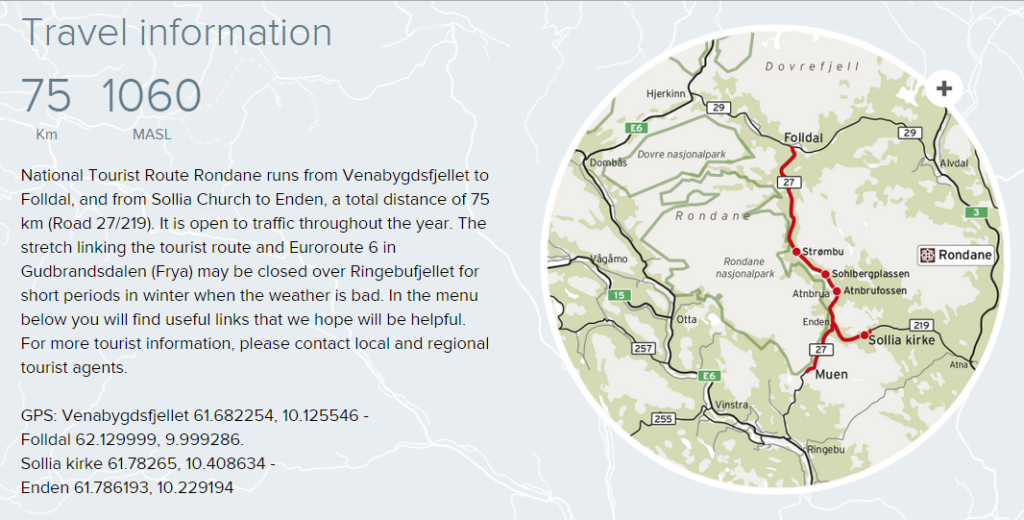
Rondane
Close your eyes and sense the mountains: over 2,000 metre-high summits in a singular landscape decked in blinding white snow, the rays of the low-hanging sun reflecting on the glittering snow, the bluish light. Tranquillity and quiet, and the knowledge that the sunny day can be transformed within moments to threatening stormy weather.
This is when you get the feeling that Rondane is a place you must visit. Perhaps it is this feeling that has led so many artists and writers to derive inspiration from Rondane – and maybe this is why people return to Rondane again and again over generations. Like ancient giants the mountains stand at rest on the road that takes you alongside the Rondane national park. Experiencing the slowly changing landscape with its towering mountains is very special – almost magical.
Here you must find repose and let your impressions sink in. The bluish light will accompany you on your way. If you have the opportunity, you should stop at the curving Sohlbergplassen viewing platform at Atnsjøen. The atmosphere in Harald Sohlberg’s famous painting from 1914 “Winter’s Night in Rondane” is bewitching. The architect wanted to recreate this atmosphere and from Sohlbergplassen you can take in the view of Rondane from the same angle as portrayed in the painting.
History
National Tourist Route Rondane is a well preserved cultural landscape relating the history of human settlement in such barren areas since the Stone Age. In 1962 Rondane was the first national park to be established in Norway. As a result the mountain roads grew in importance not only for the summer mountain farms, agriculture and transport: they also opened up for a wonderful natural experience.
Experiences
The area is perfect for families who love hiking, and offers easy terrain for children as well as activities that are easily accessible. Here you will find an abundance of tourist cabins and hiking paths that are well signposted without this detracting from the grandeur of the mountains. And the fact that you’re also in one of Norway’s most beautiful areas makes the experience quite unique.

Sognefjellet
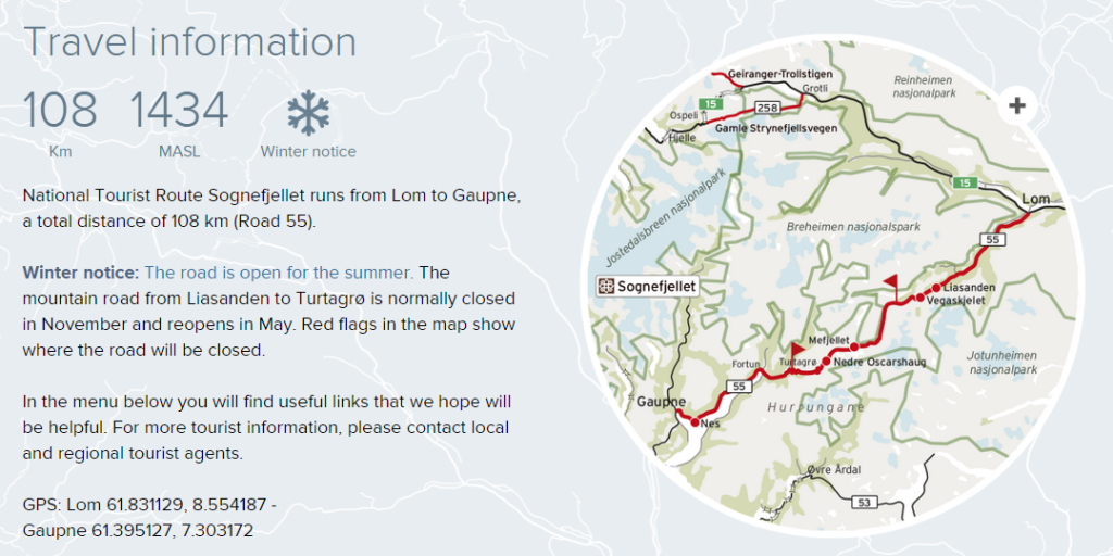
From the verdant meadows and the lush cultural landscape of Bøverdalen you can catch a glimpse of towering mountains in the far distance, as the road slowly ascends through the valley. It makes its way up to the summit at 1,434 metres, making the road northern Europe’s highest mountain pass.
From the starting point in Lom, your expectations rise even before you drive out of the small village. Not every tourist route provides such a natural dramatic setting with a profusion of powerful impressions. Along the road you will be tempted to stop at the viewing points to soak in the beauty of the natural surroundings. At the Mefjellet stop you will find Knut Wold’s stone sculpture which allows us to view the mountain landscape from a different perspective. Continuing down towards the Sognefjord the mountain region appears untamed.
Where the Hurrungane massif towers up to the heavens the mountains suddenly open up and the landscape changes once again. Towards Gaupne, the final point on this stretch, the road descends to skirt the beautiful Sognefjord whose clear waters change colour from green to blue in tune with the light and the weather. What should you do when you arrive? Relax and let your impressions sink in. Some people turn and drive the same way back, and are surprised to see how different everything is. Although everything is the same, it’s as if you see the surroundings anew.
History
The road over Sognefjellet was an important transport artery linking the coast and inland areas. Trading led to the transport of salt and fish eastwards while butter, pitch and leather were transported west. Travelling across the mountain in the old days was not without its perils – vagabonds robbed travellers and merchants.
The forces of nature can also be difficult for us humans to defy. In the winter the weather is so severe and the snow masses so enormous that it is impossible to keep the road open. If you make the trip just after the road opens in springtime, the almost ten-metre high banks of snow at the side of the road will be visible proof of the power relationship in the mountains in winter. Nature is the deciding force and this is a reminder that it is we who must adapt.
Experiences
Lom Stave Church is well worth a visit and is a good place to mark the start or end of your trip. Lom has become a kind of culinary hub in Norway and there are many opportunities to eat a fine meal with local products and delicious tastes. There is an infinite number of hiking options in the Jotunheimen mountains and almost regardless of where you stop, you will find alternatives to suit everyone – no matter what your level of fitness and ambitions.
Valdresflye
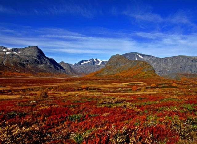
Driving in the open sweep of the landscape can be compared with the feeling of flying. The road swoops and stretches out ahead in long sweeps of undulating terrain. It’s easy to let your thoughts soar to the heights of the mountains on the horizon. The natural surroundings are both alluring and within reach, and the road hugs the landscape as a secure mooring.
The landscape can appear drowsy and friendly but the road is closed in the winter for good reasons. When winter tightens its icy clutch and remorseless winds sweep over the plateau, the huge snow masses make the task of keeping the road open too demanding. When everything is bathed in light in the summer there are no dark shadows. Regardless of where you stop you don’t need to go far before feeling you’re on an expedition.
The open landscape needs little human intervention, and the rest areas and art works blend into the background and draw your attention to individual features. Valdresflye forms a composite picture rather than presenting hidden secrets. Serenity is the dominating quality in the experience of this vast landscape.
History
The construction of roads in the mountains helped to link the various regions of Norway. More people were able to experience the mountains and the roads were very useful for summer mountain farms. The majority of mountain roads in Norway have therefore been a key factor for the tourist industry ever since they were built, allowing us to explore the mountains easily and safely. Valdresflya is a good example of such a road.

Experiences
You can make a stop almost anywhere and go for long or short hikes in the mountains. Rjupa and Vargbakkene are specially adapted stops but they are by no means the only places where you should have a break from driving. At summer mountain farms you have the opportunity to buy butter, sour cream and cheese produced in the traditional manner.

Gaularfjellet
For most people Gaularfjellet is a well-kept secret, but for all those who have discovered the road it is quite special. A journey along the road leading across Gaular, the mountain between Dragsvik and the Sognefjord, is a serene experience where the quality is in the details.
The drive skirts the fjord before snaking up towards the highest point of Gaularfjellet. At the rest area at Utsikten you can admire the panorama of mountains and valleys. The road follows Gaularvassdraget, one of the few watercourses that is protected, offering everything from wild rapids and waterfalls to calm stretches where the water glides quietly on its way.
Simply driving along the watercourse and following the natural route the water takes in its descent is a wonderful experience, but if you go on foot you can be at one with nature. A continuous “waterfall path” of almost 25 km has been established from Nystølen to Eldal. You can walk the entire length or just take a short stroll to admire the watercourse at close hand. For many people the bridge over the Likholefossen waterfall is a highlight, since it provides a feeling of being in the midst of the swirling cascade.
History
In 1853 a request was made for money to establish a road over the mountain, but almost 100 years would pass before this became a reality. The road swiftly became a key transport route after its opening in 1938, but today it is a peaceful alternative to the main roads that absorb most of the traffic.

Experiences
There are a number of simple, easily accessible places along the entire stretch of road where you can stop, stretch your legs or just admire the natural features or the view. There are endless opportunities to try your hand at fishing for brown trout, and anyone with experience of angling knows it’s just a matter of throwing out a line and waiting. Almost like driving on this road, where you should take ample time to allow the experience to sink in.
Likholefossen has been mentioned already and Balestrand, where you can also take a boat to Fjærland and visit the glacier museum, is a wonderful place to begin the trip. This is a great way to experience the fjord and an excellent starting point for the drive across the mountains.

Aurlandsvangen
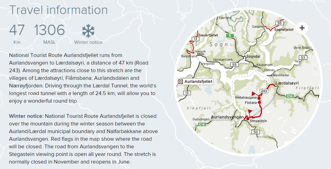
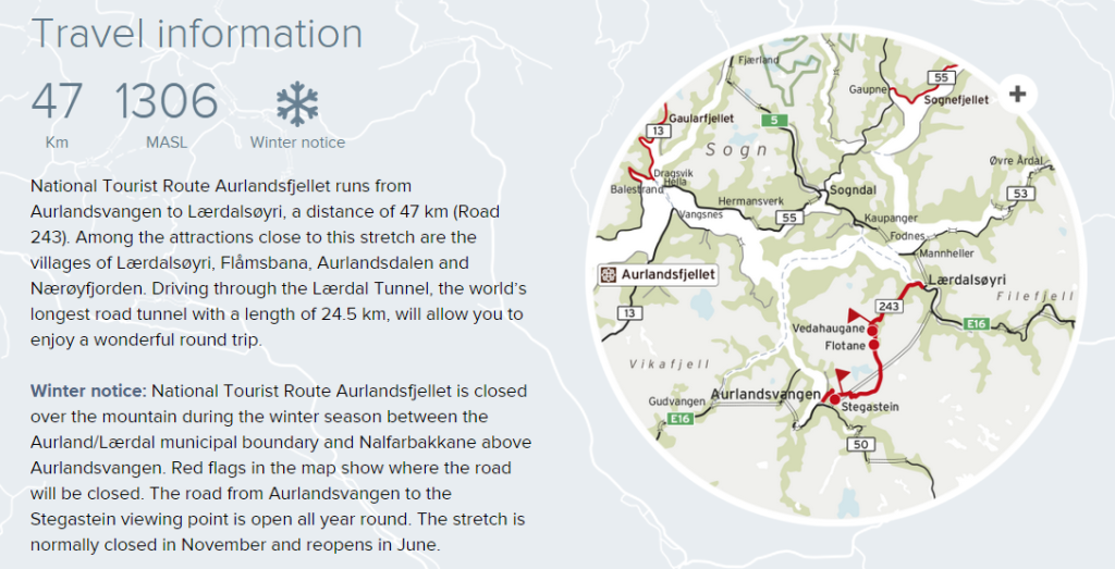
Most tourist routes are stunning no matter what direction you drive in but this particular stretch presents its most dramatic side if you start the trip at Lærdal and drive towards Aurlandsvangen. You will come away with powerful impressions, and the contrasts between the fjord and the high mountain region where snow lies on the ground for most of the year are compelling.
The road is closed in winter but the stretch from Aurlandsvangen is open as far as the viewing point at Stegastein all year round. Many people find this point as spectacular as the view. In winter especially it’s fascinating to see how the landscape changes character from the colourful tapestry of summer to a symphony in black and white with grey nuances.
We don’t always regard such things as anything special but it’s often about taking time to look. Allow time to experience the installation “DEN” by the American artist Mark Dion at Vedahaugane, and keep in mind that art is intended to stir the emotions
History
The road was opened in 1967 and its forerunner was a construction access road. The road runs from Lærdalsøyri to Aurlandsvangen over the mountains and the highest point is 1,306 metres above sea level. The road is closed in the winter and snow lies on the mountain throughout large parts of the summer, so the name “the snow road” is truly befitting.
Experiences
Sometimes it’s all about having the opportunity to experience something exactly as it is, neither more nor less. For many the feeling of being in a place where there are few traces of mankind is what makes the greatest impact at Aurlandsfjellet. It’s like being a guest somewhere you are not expected. The real quality lies in the little things, like touching the snow or dipping your toes into an icy mountain tarn. The desolate landscape itself offers something unique, and the drive takes you from fjords to mountains, from lush valleys to the stony wasteland of the high mountain region. You will encounter many striking contrasts over a short distance.
There are restrictions on the length of buses and the maximum length is 12.4 meters.
In the menu below you will find useful links that we hope will be helpful. For more tourist information, please contact local and regional tourist agents.

Hardanger
It’s no secret that Hardanger is like a picture postcard and almost everywhere you look you will feast your eyes on thundering waterfalls or fruit trees in bloom. Everything you’ve ever heard about Hardanger is true. Dramatic roads run through dramatic scenery and there is a wealth of variation to absorb.
The roads in Hardanger impose their own pace and you must adapt to the natural tempo. The road may follow a shelf along a steep-sided valley or it might literally pass through apple orchards; perhaps it is this closeness that is the unique quality of the stretch. Here the experience is in the drive.
The perfect holiday would be to drive in springtime at the height of the fruit blossoming season, stop to fish in the Hardangerfjord and then return when fruit picking is underway in late summer. Then Hardanger will reveal its unique aspects that change with the season and are all equally worth exploring.
History
Fruit has been grown in Hardanger since the 14th century, and boat building and the quarrying industry have been vital for the local community. Artists and tourists have always drawn inspiration from nature and its grandeur. Not all roads in Hardanger have retained their former importance and new and more modern alternatives have been built, but as tourist routes the old roads are as attractive and eminent as at any time.

Experiences
Waterfalls exert a magnetic attraction on us and Hardanger is the perfect destination for waterfall enthusiasts. Hardanger is framed by large waterfalls: Steinsdalsfossen, Vøringsfossen, Skjervefossen, Låtefoss and Furebergfossen. They are all different but all have the power to hypnotise us. The force of these waterfalls is so enormous that often we simply stand and stare. Discussing which of them is most beautiful then becomes merely an academic exercise. They all possess their unique qualities, like Steinsdalsfossen where you can follow the path behind the cascade, or Låtefoss with its twin falls that perhaps attracts more admirers than most tourist attractions.

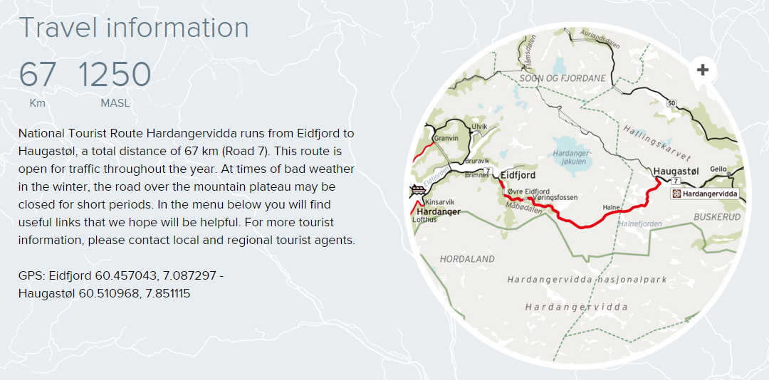
Hardangervidda
The fact that the road crosses the biggest high mountain plateau in Northern Europe tells you something about what lies in wait, but not everything. Here you will encounter vast plateaus, deep, lush valleys, high mountains, glaciers in the far distance, waterfalls and azure fjords.
Hardangervidda offers a variety of experiences starting from where the road snakes lazily across the wide plains to the narrow, steep, untamed valley of Måbødalen, until suddenly you are no longer in the high mountain region but in the little village of Eidfjord innermost in the Hardangerfjord. In winter, road conditions over the mountains change from hour to hour and often you will find yourself driving in a convoy behind large snowploughs striving to clear the road for drivers.
This is also a thrilling experience. The plateau can be inhospitable in wintertime but in summertime it is far more welcoming. The terrain is ideal for walking and you have the chance to catch your own dinner if the fish are biting in one of the many wonderful mountain tarns. Remember that at this high altitude the weather can be changeable even in summer but that in itself is an integral part of your contact with nature.
The Hardangervidda plateau boasts one of the biggest populations of wild reindeer in Europe and if you are very patient and very lucky you can marvel at these amazing animals in their proper element. Perhaps that’s when we first understand who belongs here and who is just a passing guest.
History
People have crossed the mountains for perhaps more than 1,000 years but it was only at the beginning of the last century that roads were established. Many of these follow the original paths and cart tracks, so even though much has changed, it’s gratifying to think that we are often following in the footsteps of those who roamed the mountains many centuries ago.

Experiences
Vøringsfossen is Norway’s best-known waterfall, and it’s easy to understand why it makes such an impact on people. The water thundering down the mountainside in a free fall of 145 metres is an impressive sight. The valley of Måbødalen is a spectacular part of the route and can be admired from the car window although you should perhaps make a stop to discover the rare and beautiful flora. Once you’ve reached the high mountain plateau, you will experience a stunning panorama with the Hardangerjøkulen glacier in the background.

Ryfylke
The drive along the Ryfylke National Tourist Route is a trip full of contrasts. Here you will encounter high barren mountains, lush green hillsides, sheer mountainsides and deep fjords. The Saudafjellet mountain displays special natural characteristics. It is rugged, brutal and unyielding, and you might find yourself wondering what on earth it was that persuaded someone to lay a road exactly here.
At the Svandalfossen waterfall you can walk up the steps and really feel the force of the rushing water and the might of the cascade. Sometimes the water runs so high that the police must take charge, directing cars one at a time through the mist of spray that covers the road. It is quite an exotic experience. At the southern point of this road you will find Lysefjorden.
This fjord is perhaps most enchanting when dark clouds hover above, only penetrated by bands of golden light. Since Ryfylke National Tourist Route is a long and varied stretch of road, it is worth taking your time. There are lots of opportunities on the way to make short detours and to take a break from driving, whether you are keen to find out more about Sauda’s industrial history or just want to explore one of the lovely little shore villages such as Sand.
Along this route you can take part in a salmon fishing safari and rafting, or you can set off on a hike in constantly changing terrain. The drive through Ryfylke offers a versatile experience on a challenging road with many charming aspects.
History
Hellandsbygd exemplifies how the social structure in the community was built up around energy-intensive industry and access to cheap electricity. Industry is also the reason for the actual location of the road over Saudafjell, since this was the shortest and fastest route eastwards.

Experiences
Many tourists make a pilgrimage to Ryfylke. Here you will find some of the most spectacular natural attractions Norway has to offer. Both Preikestolen (Pulpit Rock) and the Kjerag boulder with Lysefjorden in the background are popular as destinations and photographic motifs. There are also many idyllic spots along the road that are worth looking out for. In addition there are two short ferry trips where you can breathe in fresh sea air and admire the fjords at close hand.
Jæren
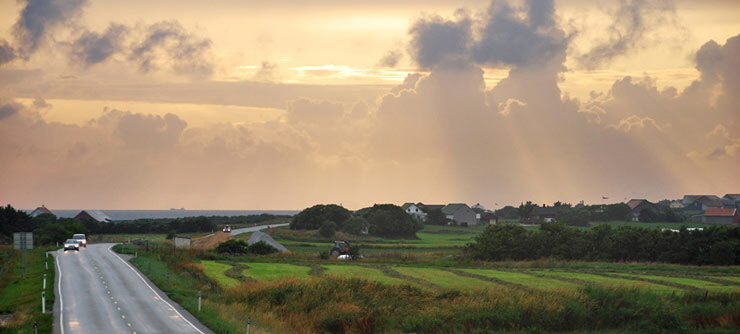
To some extent this road differs from many of the other tourist routes – it’s quite simply a regular all-purpose road. On this route you must be prepared to share the road with all those who use it every day.
Just treat this as part of the experience, and keep in mind that being stuck behind a farmer on his tractor in fact gives you a better opportunity to spot all the nuances and features of the landscape – the cultural heritage, the ocean, the fields and the eternally changing light. This coastal landscape is unique and completely unlike anything you will find in other parts of Norway. To get the strongest impressions you should probably stop the car or take time to drive on some of the little side roads.
That way you draw closer to the ocean and discover much more than you can from the main road. The beaches of Jæren are a joy no matter what the weather, and the weather changes frequently, so be prepared. It’s as if the landscape is tranquil and languid and nature is unyielding and hard, but then it can flare with explosive force. Here you are part of everyday life and it’s been said that you haven’t seen the whole of Norway if you haven’t seen Jæren.
History
It is the ocean and not the road that dominates here. Yet the road plays a key role in the big picture as it cuts through beautiful cultural landscape often bordered by old drystone walls that are not only historic monuments but also a visible link to bygone times. The road continues to be part of the everyday life of all those who live along the Jæren coast and lies ready to welcome everyone who wants to visit this unique region.
Experiences
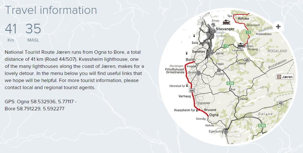
At first glance the road is uneventful but then you experience the subtle shifting patterns of light, the undulating landscape, the ever-changing sky and the horizon far out over the ocean. The beaches each have their own personality no matter where you happen to stop – you will find both sandy beaches and pebbly beaches. Orrestranda is perhaps one of the most magnificent and here you can walk for many kilometres on the white sand and admire the rich flora and fauna. Many shipwrecks have occurred along the Jæren coast and the unique coastline necessitated the development of special rescue techniques. Kvassheim lighthouse was equipped with a foghorn when it was built in order to guide shipping traffic safely past the coast of Jæren.The lighthouse is splendidly situated against the background of the open ocean. Today it is open for everyone who wants to take a break and learn something new.
Feature image (on top) Trollstigen National Tourist Route
The Beautiful Tourist Roads in Norway, source: Nasjonale Turistveier

You might also like to read:
Spectaular Driving in Norway